Friday, December 31, 2010

Big Bend National Park


Welcome to Big Bend National Park! They say that everything is bigger in Texas, and let me tell you, this is one huge park! But despite its 801,163 acres, the park is ranked 15th in size in the National Park System. (Sorry Texas, your park isn't really bigger.) But even the littlest giant is still a giant, and this park had a lot to offer. However, probably because of its remote location, this park sees a relatively small number of visitors, typically between 300,000 and 400,000 per year.

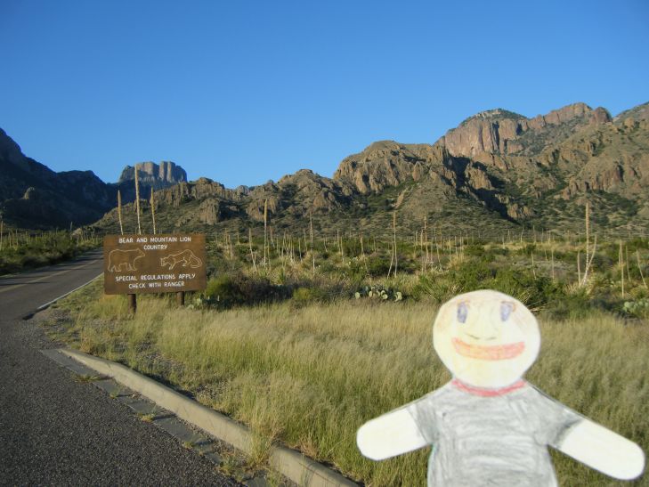
Big Bend has desert plains, sub-alpine mountains, and 118 miles (189 km) of winding, muddy river banks along the Rio Grande. The diverse landscapes provides for a rich biological diversity. Behind me in the photo above along the north access road is a sign warning of black bears and panthers. Fortunately, I didn't have any run-ins with the more-dangerous wildlife. :-)


I stayed overnight in Chisos Basin campsite, which was truly an ideal spot!


The Chisos Basin was beautiful, and it had the benefit of being at an elevation of 5401 feet (1664 meters). That means that when it's blistering hot in the rest of the park, it's only a bit warm in the basin. And that means it's the coolest place to (legally) camp out in the park, literally!


That notch in the mountain range is known as the Window. Go figure! With Big Bend being so remote, and with Chisos Basin being at a relatively high elevation, the stars at night were awesome! You could really see the Milky Way!


Driving out around Big Bend's 123 miles (197 km) of paved roads was always a delight.


Postcard anyone? :-) What a striking land! Our National Parks are a real treasure!


The rocky spires below are together called the Mule Ears. :-)


Volcanic rock, limestone, and yucca adorned this patch of ground.


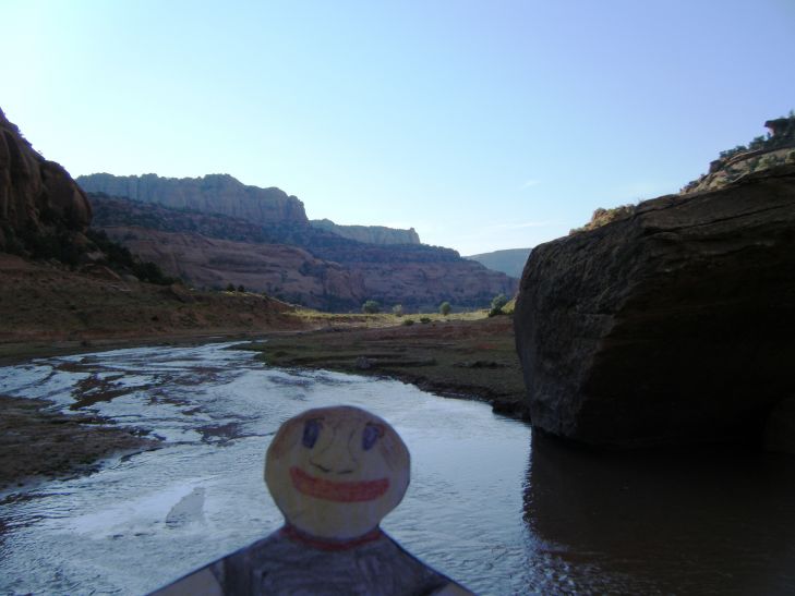
I just loved the look of this rocky bluff, with all of its prominent layers. This is near the hot springs in the park. I was on a mission to find these elusive springs.


I never did find the hot springs. :-( But at the time, it was around 100 F (38 C) outside, and clearly very sunny. I opted for a refreshing dip in this nearby cool but shallow stream. Ohhhh, that felt gooooooood!


Hiking out the Chimneys trail, I found one of the local residents. This spider was enjoying a tasty grasshopper snack. I thought the neatest thing was that this spider had built a house for himself out of small twigs. Even spiders can appreciate a little shade in this desert environment.


The desert floor with the Chisos mountains in the background was a beautiful, if inhospitable view. I loved the tall, straggly arms of the ocotillo plant, which you can see on the left side of the photo.


This was such a cool rock! Just look at all of those layers! Those layers tell a story. Was this rock formed from the sediment of some ancient pond? Did it come from silt deposits along a river bed? And how did this rock get here in the middle of the desert? Geologists would have a field day in this park!


There it is, the Rio Grande. It's not look that grand at the moment. The park's boundary officially at the deepest channel in the river. So in this one photo you see two countries! The land really doesn't look all that different on the other side. ;-)


On the western end of the Santa Elena canyon, with an "easy" hiking trail to see such sights as this boulder chock full of fossilized shells. I say "easy" because that's what it says in the brochure. But I think that the massive flood they had in 2008 made access to this trail a little less easy. I had to ford a muddy and mucky, ~2 feet (0.61 m) deep river to get over there.


And here is the view looking out Santa Elena Canyon into Big Bend. On your left, you'll notice the United States. On your right, Mexico.


Towards the end of my visit, I took a very rewarding hike along the Lost Mine trail, which included such wonderful views as this outcropping, which I think is known as Casa Grande. (No relation to the previous post.)


Up at this elevation, the climate is more forgiving, and so the diversity of plant life explodes compared to the desert floor. That doesn't stop the cacti from moving in either!


Impressive, no? I think this is known as Juniper Canyon.


There is something revitalizing about being up among the mountain peaks. I feel, I feel, not so flat. :-)


Lovely flowers in bloom greeted me near this peak.


More of the luscious landscape...


The only large animal I saw in my visit was this deer, who had no problems traversing the steep terrain.


Just beautiful. I don't know why, but I didn't have big expectations for Big Bend. Happily, it turned out to be truly a great place to explore, and a place I wouldn't mind seeing again.


Here I am at the end of the Lost Mine trail. From this vista, you can see the lost mine, which is an adjacent mountain side. The mine itself was not much to see. That didn't bother me, because I was lost in the splendor of this view. Speaking of lost, it's time I get lost in my next adventure. See you then!

Tuesday, November 30, 2010

Keet Seel


Welcome to the ruins of Keet Seel! In northern Arizona is the Navajo Reservation, which includes a special parcel known as Navajo National Monument. The Navajo National Monument contains three of the most intact cliff dwellings of the Hisatsinom people, a people which the Navajos refer to as Anasazi, translated as “ancient ones.”

The Navajo Native Americans were forcefully relocated to the lands of the Navajo Reservation in 1864 by the U.S. Army, a 450 mile trek on foot from their homelands in eastern Arizona and western New Mexico. By the time the Navajo arrived, the cliff dwellings were already vacant. The Navajos were fearful of the spirits living in the ruins of the cliff dwellings, and the areas surrounding the dwellings where the Anasazi had buried their dead. As a result, the ruins of the cliff dwellings remained unmolested until they were “discovered” by the Wetherill Brothers in 1895.

The name Keet Seel is from Navajo language term meaning “broken house.” This was actually many broken houses. In fact, it is estimated that more than apartment-like 150 rooms once made the community of the Keet Seel cliff dwelling. There were storage rooms and single family, single room dwellings.

The Anasazi grew maize, beans, and cucurbits in the rich soil of the river bed in the narrow valley, and supplemented their diet with hunted wild game when possible. Corn was often ground into meal on flat pieces of sandstone, which often lent sand grains into their food. As you may imagine, chomping down on sand grains is not so good for your teeth! The teeth of the skulls have been found with heavy wear on there grinding surfaces.

It is suspected that settlement of the cliff began around 950. The community remained small until new and varied immigrants settled in around 1250. This wave of immigration is reflected in the different construction styles of the new rooms as well as the addition of several Kivas, chambers for religious ceremonies. Keet Seel had an estimated six Kivas, suggesting multiple varieties of faith, or perhaps specialization of rituals.

Yet despite this influx of people, Keet Seel would be abandoned shortly thereafter around 1300. It is not clear why Keet Seel was abandoned, but a prominent theory is that a combination of a 13 year drought and followed by heavy erosion through flooding made life in the river bed beyond reasonable.


Well, as they say, getting there is half the fun. They just don't tell you that it's nine tenths of the effort! It was a fun and beautiful hike to Keet Seel... a hike which began with a 700 foot descent into the river valley below. :-)


Check out this rock formation that looks like a big ship!


There were a handful of waterfalls to see along the way to the ruins. Did I mention that this was a river valley? Yeah, I had to cross the river probably about 20 times to get out there.


There were some cool sights along the way to keep things interesting, like this rock wall which looks like it could have inspired a cubist painter.


And this layered sandstone formation which looked similar to what you find in shale.


There was natural beauty all around, from flowers to the colorful rock layers.


OK, so here I am at the entrance to the ruins of Keet Seel. It was only about a 11 mile hike. One way! ;-) You can't really see the dwelling, but you can see the alcove in the cliff where they dwelling was built. It was huge!


This composite photo shows the span of the dwelling, roughly 180 feet wide!


Viola! The Keet Seel Ruins! on the right of the photo you see a shear drop off that was about 30 feet high. There was not a real easy was to get up to these dwellings until the National Park Service installed a permanent ladder.


Just think: all of these stones had to be brought up the side of the cliff wall to be assembled into houses. There was no elevator, no ladder, and no real stairs other than small foot-sized ledges carved into the cliff face.


On the wall of the cliff, there were a few paintings. I swear that one looks like a guy with a turkey growing out of his head. :-)


Here you can see a stone which was used for sharpening tools.


Pot shards were all over the place!


Below is a collection of small treasures which the ranger found, including an arrow head, a bone awl, a piece of a fine-beaded necklace, and a piece of rope wrapped with owl feathers.


The construction of the roofing was fairly simple; large sticks, crossed with small sticks, and covered with mud.


These were multi-story dwellings, and tight quarters for sure.


Here you can see the entrance to one of the rooms. There is a half-wall just inside the door which kept incoming drafts from blowing out the cooking fire.


You can tell by the soot on the cliff ceiling that there were quite a few home fires burning.


Here is the underside of a roof, blackened with soot. You can also see some rope made from yucca fibers.


This is a view down into one of the six Kivas at Keet Seel. The Kivas were circular, and had a circular fire pit just inside the doorway. You can imagine the shaman singing some incantation into the chilly night air. The alcove of the cliff was a perfect amphitheater, as even with my tiny, flat lungs I could make such an echoing raucous that I felt twenty times larger! I could just imagine how impressive a shaman's ceremony would be!


Here is a good photo showing a couple different building styles. You can see both walls made of stone as well as walls made from mud applied to upright sticks.


This was the coolest thing I saw on the way back! You'll probably have to click on the image for a larger view, but what you see here is a miniature cliff dwelling! These "ruins" were only about two feet tall, and were probably used by the children of the Anasazi just like doll houses are used by modern kids.


The light is getting dim, and I still have miles to go before I sleep, and miles to go before I sleep. So I better get a move on, so I can rest my tired, wet, wrinkly feet before dark! See you next time!

Sunday, October 31, 2010

Casa Grande


Welcome to Casa Grande! This mysterious structure marks the United States' first archeological preserve, attaining legal protection status in 1892. It was built sometime before 1350 by a group of native Americans known as Hohokam. The Hohokam may be the ancestors of the Pima Indians, as they had explained to a group of missionaries led by Father Eusebio Kino in 1694 that their ancestors were “ho-ho-KAHM,” which means “all gone” or “all used up” in their language.

Casa Grande, or “big house,” is located in Coolidge, Arizona, south of Phoenix, and near the Gila River. The mystery of the big house is its purpose. It may have been the residence of the tribe leader, but there is obviously more to it than that. Each wall is set according to the four cardinal directions. There is a circular hole in the upper west wall that aligns with the setting sun on the day of the summer solstice, and other such openings align with the sun or the moon at other significant times throughout the year.

This attention to the earthly calendar fits well with the consideration that the Hohokam were an agricultural community. Keeping note of the timing of the seasons would help such a community thrive. Their ingenuity was not solely limited to astrology though, as they also developed a canal irrigation system to water their crops and refresh themselves.


The building itself is constructed of a wooden frame made from hundreds pieces of juniper, pine, and fir trees. That is remarkable, because those types of trees are located about 60 miles away! A hard earthen cement made of sand, clay, and calcium carbonate, called caliche, was then applied to the frame up to 4 feet thick at the base, tapering thinner as you work towards the top of the structure.


These ancient people made many decorative petroglyphs in stones like this one. They had irrigation and art. This was one happening desert settlement!


This was my favorite petroglyph! I mean, what is it? A floppy-tailed goat? A fat cat with long ears? A mangled ant with no abdomen? It could even be an accurate sketch of an extinct animal! Whatever it is, I liked it.


Well, that's it for me for here. I know, it was a short visit. But life is like that sometimes. You've got to cherish the little time you have. Until next time...